|
Benton County, as it is currently configured, occupies 408
square miles of land, and 5 square miles of water, in central
Minnesota. Its western border is the Mississippi River. The population
in 2010 was 38,451. The largest city is Sauk
Rapids, about 60 miles upstream from Minneapolis. Since the beginning,
the population of the county has been concentrated near the Mississippi,
with Sauk Rapids accounting for at least 1/6 of the total.
St Cloud, the largest city in the region, lies mostly in Stearns County.
However, part of St Cloud extends across the
river, into Benton and Sherburne counties. The village of Sartell also
lies mostly in Stearns county, but extends over the Mississippi,
to include a part of Benton County. The village of Royalton is mostly
in Morrison County, but its southern part extends into Benton County.
Contained in Benton County are Foley, Gilman, Rice and Sauk Rapids.
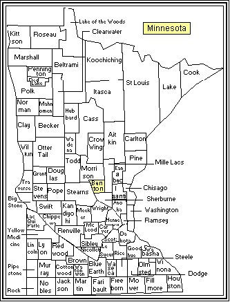
This map shows the 87 counties of Minnesota, with
Benton County in the center.
In the west-central part of the county is the city
of Foley, the County Seat. The County's most populous city,
Sauk Rapids, is on its western edge and adjoins St. Cloud. The median
home value of existing homes in Benton County was $170,800, according
to the 2010 U.S. Census. The average median sales price of an existing
home in Minnesota in 2010 was $206,200. Counties with the greatest
long-term gains in median housing sales prices are generally close
to the Twin Cities area and the
southeastern part of the state. The largest industries in Benton County
are services, non-durable goods, manufacturing, retail, and durable goods
manufacturing.
Other statistics from the 2010 U.S. Census:
Population: 38,451
Percent of population growth 2000-2010: 12.3%
County area - 413.00 square miles (408.28 square miles land,
4.72 square miles water)
Persons per square mile: 94.2
Housing units: 16,140
Median value of owner-occupied housing units (2006-2010): $170,800
Homeownership rate (2006-2010): 70.6%
Persons per household (2006-2010): 2.50
Median household income (2006-2010): $50,848
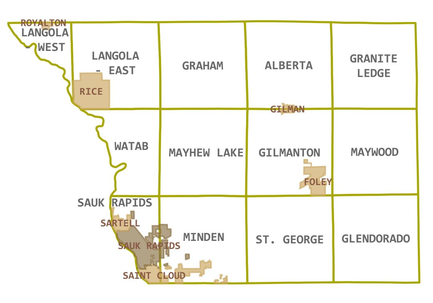
Townships and Cities in Benton County
The Mississippi River drops from 1030 to 980 feet above sea
level as it flows past Benton County. The water in Benton County flows
generally southward, with creeks joining
the Elk and St Francis rivers, which flow south into Sherburne County,
where they merge before emptying into the Mississippi.
Minnesota is famous as the "land of 10,000 lakes," but Benton County
doesn't seem to have its share. Only 5 square miles (
officially, 4.757)
of the county are covered by water. About half of that (2.27 square miles)
is in a manmade reservoir,
Little Rock Lake. However, Benton County lies between
Mille Lacs
(which means 1,000 lakes), a lake of 207 square miles - over half the
size of Benton County - and the Mississippi River. The Rum River,
an important logging channel, flows
south from Mille Lacs, through the part of eastern Benton County that was
added to Mille Lacs County, and empties into the Mississippi. So Benton
County is surrounded by water, and this has played a vital role in its
history.
The term "township" is used in two ways. First, it refers to a vertical
coordinate. The county is divided by east-west lines, 6 miles apart, into
Townships 36, 37 and 38 North. It is also divided by north-south lines
6 miles apart, into Range 28 through 32 West. This creates 6-by-6-mile
squares, also called townships. These townships can be referred to by
their Township-Range coordinates, and also by the names they are given.
For example, in the northwest corner is Granite Ledge Township, also
known as T38N-R28W. The exception is Langola, which is T38N-R31W
(Langola West), with an extra bit from T38N-R32W (Langola East).
Of course, some of the 6-by-6-mile squares extend outside the county,
and the corresponding townships are thus limited. Besides that, each
township is divided into 1-square-mile sections, numbered from 1 to 36.
For this purpose, Langola township has sepaerate numbering for Langola
East and West.
Below is a brief gazetteer of Benton County, by township. Population
figures are from the 2010 US Census.
Alberta Township T38N-29W
Pop. 818, not including Gilman.
Contains the northern part of the village of
Gilman, pop. 224. Gilman is a separate entity
from the township. Alberta also contains the
unincorporated communities of Jakeville in the SW corner, North Benton
in the center, and Brennyville in the NE corner. The
Elk River (a.k.a. Kabitawi) runs
southward through the middle of the township. The
highest point in Benton County, at 1,316 feet above sea level,
is near the gravel pits in the northeast corner of Alberta Township.
Gilmanton Township T37N-29W
Pop. 841, not including Gilman and Foley.
Contains the southern part of the village of
Gilman, pop. 224.
Also contains the city of
Foley, the county seat, pop. 2,603. Both Gilman
and Foley are independent of the township. The city website has a
history page. The
Foley Minnesota Gallery has several photos, some dating back to 1910.
In the NW part of the township is the unincorporated community
of Bushville.
Glendorado Township T36N-28W
Pop. 762. Contains only the unincorporated community of Glendorado,
in the SE corner. The St Francis River runs southward through the
west part of the township.
Graham Township T38N-30W
Pop. 582. Contains the unincorporated communities of Silver Corners
in the SW and Novak's Corner on the east side.
Granite Ledge Township T38N-28W
Pop. 743. Contains the unincorporated communities of Granite
Ledge (NW corner) and Rum River (N center). The west branch
of the Rum River runs into the township from the north, and
out the east side. The St Francis River runs southward through
the eastern part.
Langola Township T38N-31W and T38N-32W
Pop. 906, not including Rice, pop. 1,275 and Royalton, pop. 1,242
(mostly in Morrison County). Both Rice and Royalton are sepaerate
entities. Rice was formerly called Rice's Station, or Rice's.
Langola Township is in two parts: East and West. Each part
has its own numbering system for one-square-mile sections. Contains
the north part of
Little Rock Lake. The township has a
website.
Mayhew Lake Township T37N-30W
Pop. 831. Contains the unincorporated communities of Mayhew
(NW corner), Fruitville (N center), and Popple Creek (SE corner).
Also contains a lake called Mayhew Lake, apparently a wide spot in
Mayhew Creek.
Maywood Township T37N-28W
Pop. 954. Contains the unincorporated communites of
Ronneby (was
dissolved in 2009) and Oak Park.
(Note: there are other communities in Minnesota called Oak Park.)
Minden Township T36N-30W
Pop. 1,664. Contains some of the eastern parts of the cities of Sauk Rapids
and St Cloud. (Most of St Cloud is in Stearns County. The part that extends
across the Mississippi, into Benton and Sherburne Counties, is sometimes
called East St Cloud.) Elk River and Mayhew Creek both run more or less
southward through the township.
Sauk Rapids Township T36N-31W
Pop. 584 not including the city of Sauk Rapids, pop. 12,773.
The city ond township together make up 34.7% of the county population.
Like Gilman and Foley, the
city of Sauk Rapids is independent of the township.
Sauk Rapids Township also contains portions of St Cloud and
Sartell, that extend across the Mississippi from Stearns County.
The north part of Sauk Rapids is called Osauka on some old maps.
St. George Township T36N-29W
Pop. 1,153. Contains the unincorporated communities of Parent
in the NW corner, and Duelm in the south.
Watab Township T37N-31W
Pop. 3,093. Contains the community of Watab, which, although
highly urban, is not incorprated as a city. The township also contains
the south half of
Little Rock Lake, a small lake that has been enlarged
by a dam. Watab Township has a
website.
|